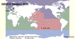
GEBCO Seabed Mapping – Nineteen Percent Completed
— June 26, 2020The mission to map the world’s seabed’s by 2030 took a step closer to completion with the announcement of the inclusion of 14.5 million square kilometres of new bathymetric data in the latest GEBCO Grid. The Nippon Foundation – GEBCO Seabed 2030 Project was launched in 2017 when only six percent of the oceans seafloor had been mapped to modern standards. That coverage has, in three short years, risen to nineteen percent.
Jamie McMichael-Phillips, Seabed 2030 Project Director, said:
“The sustained increase in data available to map the ocean floor will enable Seabed 2030 to play a leading role in delivering a comprehensive set of authoritative data that is freely available for all to use. This is a leap forward towards achieving our mission, by the year 2030, to empower the world to make policy decisions, use the ocean sustainability and undertake scientific research based on detailed bathymetric information of the Earth’s seabed.”
The General Bathymetric Chart of the Oceans (GEBCO) is a joint project of the International Hydrographic Organization (IHO) and the Intergovernmental Oceanographic Commission (IOC) of UNESCO – the United Nations Educational Scientific and Cultural Organization. It is the only intergovernmental organisation with a mandate to map the entire ocean floor. It has its origins in the GEBCO chart series initiated in 1903 by Prince Albert I of Monaco, and aims to provide the most authoritative, publicly-available bathymetric datasets for the world’s oceans.
On the 9th of June 2017 New Zealand joined in this initiative when the National Institute of Water and Atmospheric Research (NIWA) was tasked with coordinating the collection of data for the waters around New Zealand. No small task when that designated area is 25% of the world’s ocean area. The centre, based in NIWA offices in Wellington, is the South and West Pacific Ocean Regional Data Assembly and Coordination Centre, which is jointly operated by GNS Science and Land Information New Zealand (LINZ).
The area covers the Pacific Ocean from South America to Australia, north of latitude 50°S to 10° north of the Equator and the western part of the Northern Pacific Ocean to Japan and includes the world’s two deepest trenches—the Mariana and Kermadec Trenches, both of which are more than 10km deep.
The global benefits that will be derived from this mapping are enormous. It will increase the understanding of ocean dynamics which is a major contributor to the global climate. Second only to the influence of the sun. It will also allow better modelling of wave and tsunami propagation. For New Zealand, the full and detailed mapping of our immediate vicinity, out to at least the boundaries of the EEZ, will be of great benefit in planning further research into the surveys of the areas with oil and gas potential.
Research, including high resolution bathymetry, seismic surveys and core sampling needs to be expanded within the New Zealand EEZ. This research is needed so that we have a clear understanding, backed by sound science, of our resources in oil and gas. It is estimated that these reserves are vast and once confirmed they could be the single biggest source of wealth for all New Zealanders.
Dennis Knox
OSSeas Consulting
-

By: Dennis Knox
CEO of Seastrata Energy Ltd and CEO of OSSeas Consulting. Project Manager in the offshore energy construction and installation industry with 25 years experience.
-
-
Greenhouse Gas and Guesstimate Science
Nanotech Solar Energy Device to Produce Hydrogen
Romper Stomper Plastic Chomper
New Zealand Gas Resources
Clean Green Natural Gas
See all this author’s posts
Related Articles
-
-
Nanotech Solar Energy Device to Produce Hydrogen
June 12, 2020 -

Romper Stomper Plastic Chomper
June 5, 2020 -
New Zealand Gas Resources
May 29, 2020
Leave a reply
You must be logged in to post a comment.